Robyn and I have been travelling with Matt and Kathrin for almost a month now, exploring the coastline of South Australia as well as a bit of an “outback” detour to the northern Flinders Ranges. We have seen lots of the wildlife of the area, often having emus wander through camp, kangaroos hop past the tent at night and all manner of birds screeching at dawn.
Our only encounters with dolphins had been occasional visits by small groups off Pt Lincoln National Park and a large pod of 30 whizzing by near Pt Longnose in Coffin Bay, until Kathrin and Matt decided to go for a walk along the cliffs.( Unfortunately Robyn and I spent the time relaxing and missed all the fun.)
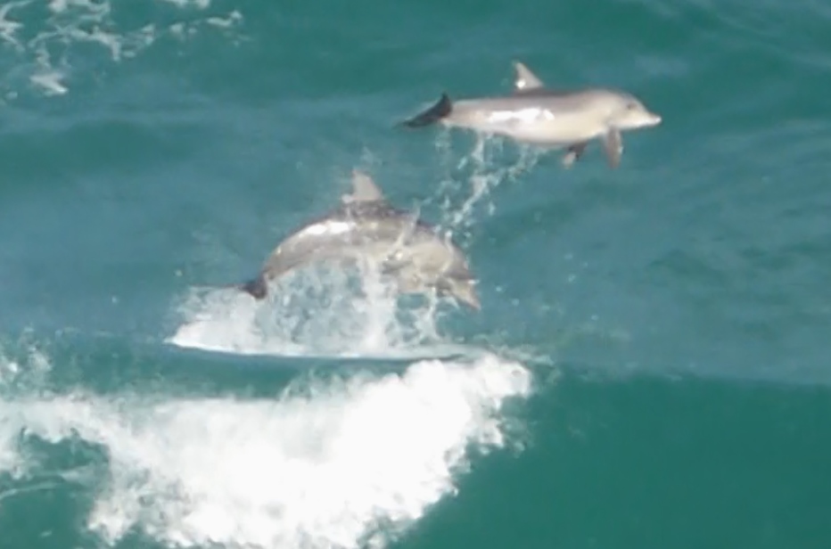
A Super Pod of Dolphins had moved into the bay, numbering well over 100 in one end of the bay. They were surfing and jumping waves and generally having fun. Matt and Kathrin only had a small “point and shoot” camera with them so the footage is a little shaky but certainly worth viewing in full screen mode and 360/480.
On the road again, this time with Matt and Kathrin who are visiting from Germany. Loaded with 2 double sea kayaks we travelled towards the west coast of South Australia in temperatures above 40 degrees C.
The trip plan was to spend time in remote locations, paddle the coastline, swim with dolphins and sea lions, see lots of Australia’s wildlife and enjoy a few red wines along the way.
Passing through Kimba, know as the town “halfway across Australia” or “middle of nowhere” you just have to have a photo taken in front of the “Big Gala”.Huge flocks of these noisy birds are common in this area.
After two days travelling, we set up camp and Matt and Kathrin enjoyed a relaxing 18km paddle in a shallow protected bay, to check out their borrowed kayak..
.
Next day was Dolphin Day when we swam with a large pod of dolphins and then spent time frolicking with Sea Lions. It sounds easy to film a pod of wild dolphins but the reality was far from that. They were in turbid water and were either going too fast to film or too close to get anything more than a fin in the frame. Still it was a fantastic experience to swim with the wild pod, Although the visibility wasn’t the best we managed to get some photos and video.
The sea lions of course were much easier to film as they played with us however only a few of them seemed interested in our games.
I am often asked where to paddle in the Adelaide area, so I have put together a few details on one of my favourite training paddle.
Seacliff beach to Hallet Cove and return, passing Marino Rocks and the Hallet Cove Conservation Park. This area is only 18km from Adelaide centre by road and is a well known haunt for kayak paddlers of all types and kayak fishers looking for squid and whiting. It starts at the southern end of the sandy metropolitan beaches of Glenelg, Somerton, Brighton and Seacliff and follows the rocky coastline past Marino Rocks to Hallett Cove, and gets you away from most of the crowds.
This slideshow requires JavaScript.
The beach launch at Seacliff is accessible by 4WD vehicles and adequate car parking is available nearby, although the area becomes quite busy in summer. Alternative launch sites are at nearby Burnham Road and Marino Rocks. Both of these places have old boat ramps which are now unusable for boats but suitable for kayaks with care.
From Seacliff Beach the paddle heads south towards the headland of Marino Rocks. Once a popular seaside holiday place for early Adelaide residents it is now part of suburbia but still maintains some character with the early buildings housing an excellent Fish Restaurant. As you pass the old Marino boat ramp the Marino Reef system is on your right although not visible. Often there will be a dive boat anchored on this low reef system. A great place for diving and spearfishing in my youth (now illegal to spearfish in this area) the landscape has changed little in the last 50 years except that the houses on the cliff have changed from modest beach shacks to large “sea view” properties.
Continuing south I prefer to stay in close to the rocky coastline getting a better view of the rugged coastline and also blocking out suburbia of Marino that invades the cliff top, however watch out for the occasional dumping wave along this area, unless you like being upside down in the rock garden. Marino is an established residential area, with conservation areas in the south and is thought to be named from the Aboriginal word “marra” meaning “a hand”, or “marrana” meaning “the hands or paws”.
Settlement of the area dates from the late 1830s when the first land grants were made and land was used mainly for farming and quarrying with the population being minimal until the 1880s. Growth continued in the early 1900s, aided by subdivision of land and the opening of the Willunga railway line in 1913 (now gone). Significant development did not occur until the 1960s, when many local quarries closed and housing was built.
As you paddle south from the Marino Rocks car park and ramp you will see the Coastal Walk and the Marino to Willunga Rail Trail high on the cliffs. The boardwalks continue to Hallett Cove and are well worth the walk to get a great view of the area.
The seascape remains the same as you paddle past the Hallett Cove Conservation Park with small boulders guarding the steep cliffs. An extract from website http://www.nationaltrustsa.org.au gives some history of the coastal formations.
“The geological formations found at Hallett Cove Conservation Park tell a story that begins approximately 636 million years ago during the Proterozoic Eon, with five different geological periods represented in the park .…..The Black Cliff, the cliff line to its north and the shore platform below are composed of late Proterozoic sedimentary rocks which were deposited sometime between 636 – 590 million years ago. Extreme pressures moulded the rock into complicated fold patterns (Cooper et al., 1972). The top of the Black Cliff is the crest of a large fold, eroded and planed off by an ice sheet during the Permian, which resulted in the glaciated pavement that was discovered by Professor Ralph Tate in 1875 (Giesecke, 1999). The smooth siltstone pavement resulted from rock flour frozen in the ice sheet polishing the rock as it moved and the striations were caused by larger rocks (Cooper et al., 1972; Giesecke, 1999).
There are a number of large quartzite and granite boulders known as ‘erratics’ located in the park. These rocks were transported to the area by an ice sheet during the Permian and subsequently deposited when the ice sheet melted. One of the large erratics on the beach is a boulder of dark coloured Sturt Tillite from the Sturtian ice age (approximately 750 million years ago).
I like to paddle the area on a rising tide which allows me to get in closer to the coastal formations and inspect the submerged rocks, although sometimes too closely. Arriving at Hallett Cove the paddler has the choice of landing on a slippery rock strewn beach and getting a coffee at the cafe or heading back . There is a small creek entering at the southern end of the cove and affords a slightly better landing spot at higher tides, however, the main feature of the beach area is rocks and more rocks.
The area is also the haunt for a local dolphin pod and it is not unusual to see family units gliding along with you. There are also a small number of seals that frequent the area. It is important not to paddle towards either the dolphins or seals, (it’s illegal to come close) and I have found that if you stop paddling and keep quiet they will come to investigate you -allowing for some great photos. I have often been buzzed by dolphins while paddling along quietly. During summer months it is also possible to see squid and small fish darting around the weed line as well as large jelly fish floating by. A lovely area to paddle either on a fast training run or a leisurely coastal cruise.
The best thing is the SW prevailing wind which can give you a nice ride home under sail.
Distance 11km total
Tide floods north, ebbs south
Wind SW prevalent afternoon sea breeze
Pros Easy paddling in calm conditions, great seascape and dolphins often seen
Cons No exit points, rocky exit at Hallett Cove, rough conditions on SW winds.
Just got back from a week paddling around Thistle Island, near Pt Lincoln in Spencers Gulf. It seems that everytime I go over there I come up against headwinds, maybe it’s something I said to offend the weather gods.
Still we had a great paddle along the coast for 2 days and then out to the islands, camping on Thistle Island for a couple of days. A great trip with Mal H, Mal B, Miss Kathy, and Donna the photographer.
I came back with some great video, especially of a feeding frenzy of dolphins and birds. They had a school of fish on the surface and were really getting into them. Ofcourse I’m not sure what drove the fish to the surface but I can guess. Ofcourse Donna had 750 photos !!!! which means my video stuff will be saved by her stills.